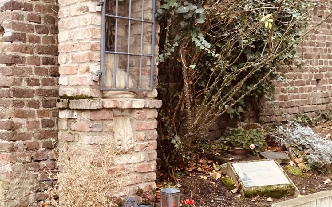
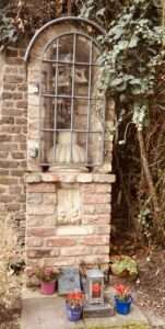
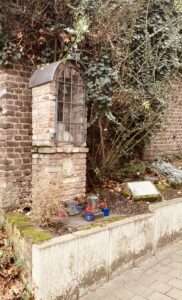
by Gert Fischer | May, 2026 | EN, history, Rhine region
Bonn last experienced a flood on the Rhine in January 2025. The water level rose to just under 7.50 m, exceeding the lowest flood mark by half a metre. No big deal for long-time residents of the Rhine. First on the right bank of the Rhine in Beuel and then at a few other locations, the riverside promenades were closed off. The car ferries could no longer be reached, and an important tram service was suspended as a precaution. Nothing happened. It was more of an opportunity for a Sunday outing on the banks of the Rhine.
-
-
The flood disaster of 1784 was quite a different matter. Apart from two extreme cases in the 14th century, about which there are no precise records, it was by far the worst flood event on the Rhine in historical times. Although the Bonn Rhine gauge has only existed since 1820, the flood of 1784 can be reconstructed. It reached over 14 metres, which is 4 metres higher than any other flood in the last 650 years. On the right bank of the Rhine, the floodwaters extended as far as the area of today’s Beuel railway station. With the exception of Wolfsburg, a medieval moated castle, all the houses here were destroyed. Even in Bonn, which is normally flood-proof, the districts facing the Rhine, including the Jewish quarter, were severely affected. The water is said to have even reached the rear of the city centre via the former city moat and to have stood in the cloister of the cathedral. The fact that there were hardly any deaths or injuries was due to the particular nature of this flood. Whilst ‘normal’ floods are the result of rain or snowmelt in the major tributaries and move relatively quickly along the Rhine as a flood wave, this time ice played a major role. Arctic temperatures prevailed for more than two months, repeatedly interrupted by heavy snowfall and brief periods of thaw. The ice floes piled up to form barriers; the water could not drain away and, weeks before the actual disaster, it slowly rose higher and higher. This at least gave people time to save themselves and their animals. When the ice dams finally broke at the end of February, it was the ice floes that caused the greatest devastation.
The Bonn area has been familiar with flooding ever since people have lived here. The city and the settlements from which it grew are situated in a landscape shaped by the Rhine. Between the Siebengebirge and the Ennert in the east and the Kottenforst and the Venusberg in the west, it has carved out a valley funnel that is still criss-crossed by former river branches. They are still there, but are barely recognisable in today’s cityscape. People have been slow to settle in this landscape. The earliest traces of human habitation come from the slopes of the Venusberg and the Ennert. The lower terrace, lying only slightly above river level, was settled relatively late; specifically at carefully selected points safe from flooding. Here, a few metres could make all the difference. The area of what is now Bonn’s city centre has always been the safest. Its highest point on Acherstraße lies about 20 metres above the zero line of the modern Bonn water gauge.
Old settlement centres such as Muffendorf, Friesdorf and Rüngsdorf in the south of Bonn are similarly safe. Parts of the urban area on the right bank of the Rhine, in the vicinity of the former town of Beuel, remain significantly more at risk to this day.
Anyone wishing to learn more about what the Rhine’s floods can still mean for Bonn today is recommended to take a walk along the Beuel bank of the Rhine. Here, at various points, there are markers documenting past floods, and everywhere the walls and floodgates that form the first line of defence are visible.
-
-
Today, this provides protection up to a water level of 9.50 m, with a second line behind it offering protection up to 11.50 m. In Rheinaustraße, the ground-floor flats in many buildings are actually on the first floor. The actual ground floor houses only garages and storage rooms – a reminder of a time just a few years ago when an 8.50-metre flood reached this far. The flood defences are particularly robust in the north of Beuel. The Rhine embankment towards the mouth of the Sieg is not only a lovely walking path, it also provides protection against floodwaters up to 11.50 metres. There is nothing comparable along Bonn’s Rhine promenade. Whilst south of the Alter Zoll the buildings have always stood high up on the steep slope, the urban districts further north were secured by raising the riverbank; once in the second half of the 19th century during the construction of the Rhine promenade, and most recently immediately after the Second World War. At that time, the rubble from the bombed-out old town was used to raise the Rhine bank by almost two metres. The original height can still be seen at the foot of the bridge pier, where a section of the old promenade has been preserved.
The years 1993 and 1995 demonstrated that dramatic floods still occur even today. In both instances, the 10-metre mark was exceeded. The fate of the so-called ‘Schürmann Building’ made headlines. Originally planned as an extension of the Federal Parliament building and now the headquarters of Deutsche Welle, its shell was pushed upwards by the groundwater from the 1993 flood and subsequently stood at an angle. Those responsible did not, as had actually been planned, flood the underground car park at the time, because the ventilation system intended for installation was being stored there temporarily. The damage was enormous. Nevertheless, the federal government decided against demolition and in favour of completing the building. It was the events of these two years that led to a significant strengthening of flood defences, particularly on the right bank of the Rhine. This included a major overhaul of the sewerage system to prevent water from entering via this route.
Even though the focus these days tends to be on the average water levels that have been falling for several decades – thanks to climate change – because they jeopardise the Rhine’s functionality as a waterway, the issue of flooding will continue to be a concern for Bonn in the future.
by Gert Fischer | May, 2025 | architecture, EN, Rhine region
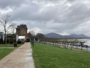
Anyone strolling along Bonn’s Rhine promenade usually has their eyes fixed on the river and the sights on the horizon: the Siebengebirge mountains, the government district or the Schwarzrheindorfer Doppelkirche church, for example. But it’s worth taking a look to the right at the landing stage of the ‘Köln-Düsseldorfer’ shipping line. At the lower end of Vogtsgasse, in the shadow of the retaining wall of the Department of History, there is a small wayside shrine. It commemorates the Gertrudis Chapel, which stood a few metres away and has now been almost forgotten. Like the entire old town of Bonn, it was destroyed in the air raid of 18 October 1944. What remained of it was literally buried in the rubble. Shortly after the war, the mountains of debris in the city centre were used to raise the area between Belderberg and the banks of the Rhine by several metres. Unattractive new buildings from the 1950s were erected on what was once the ‘Rheinviertel’ (Rhine district).
The chapel was dedicated to Saint Gertrude of Nivelles, who lived in the first half of the 7th century. As a patron saint, she had a very broad portfolio. She was invoked against plagues of rats and mice (hence the mice as her attribute), and was considered the protector of travellers, pilgrims and sailors, gardeners, spinners and even cats. In addition, her historically documented commitment to nursing and the education of girls and women is still remembered today.
It was probably these diverse connections that brought together a rather unlikely cooperation: the ‘Schiffer-Verein Beuel 1862’ (Beuel Boatmen’s Association), the Bonn Women’s Museum and the Bonn drag artist Curt Delander joined forces to ensure that the wayside shrine was built in memory of the chapel. It was built from bricks from the destroyed old town and stones from the St. Gertrudis Church in Nivelles (Belgium), which was destroyed by German bombs. This makes it a small memorial to peace, and it also reminds us that reconciled enemies drank the ‘St. Gertrudis Minne’ in the Middle Ages.
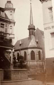
The building, which was destroyed in 1944, was not an architectural gem and no longer had any great spiritual significance. It was a simple single-nave hall building from the 15th century with modest furnishings. It was originally located directly behind the city wall next to the ‘Gierpforte’ whose name is derived from ‘Gertrud’. Even after the wall was demolished in the 19th century, there was no unobstructed view of the Rhine. A hotel building between the riverbank and the chapel ensured that the backyard situation remained unchanged. The parish church of the district was St. Remigius on what is now Remigiusplatz, with the Gertrudiskapelle chapel merely a branch. For a long time, its main users were the local boatmen and their brotherhood. This Cinderella existence may explain why there was hardly any opposition to the demolition of the little church.
Despite its unattractive exterior and its minor importance at the time, the Gertrudiskapelle was considered the ‘most distinguished’ church in Bonn after the cathedral in the oral tradition of the 19th century. Even back then, this statement did not fit with what was known about its history: first mentioned in 1258, a small hermitage of Cistercian nuns, later a temporary home for Capuchin and Franciscan Recollect monks – each before they moved into their spacious new monasteries. In 2010/11, an archaeological excavation with sensational results revealed just how much truth there can be in oral tradition. It found the remains of two previous buildings – the earliest dating from the 8th century and thus Carolingian and about as old as the two oldest inner-city parish churches, St. Remigius and St. Martin. It is very likely that this first chapel was dedicated to St. Gertrude. This can be deduced from the fact that, like Remigius and Martin, the name was often used for churches in the Carolingian period – no wonder, since the historical Gertrude was one of the leading figures in the lineage of Charlemagne.
We do not know whether this first Gertrudis Chapel was built as a parish church or whether it has a different origin. In any case, by the middle of the twelfth century, it must have been the spiritual centre of a fairly extensive settlement along the Rhine, as evidenced by archaeological finds. This settlement lost much of its importance during the Middle Ages, and with it the Church of St. Gertrude. Today, the small wayside shrine on Vogtsgasse is the last link to this period.
by Annette Bohlen | Jan, 2025 | architecture, EN, points of interest, Rhine region
I remember well the cement factory, which was vacant in the 1990s (we called it the ‘ghost house’), which we had to go around on the bike path to Königswinter. Today, here – on the sunny side of Bonn – it is a very popular meeting place at the weekend. Cyclists take a break here, families use the lawns and play ground, and pubs and restaurants entice you with food and drink.
The history of the Portland cement factory ended in the 1980s. Then began a long and varied process of planning, tendering and competitions to determine what could be built there.

Rhine promenade with Portland Cement building in view
Finally, an outstanding example of the transformation of an industrial site was created – and is still being expanded – on a beautiful new Rhine promenade. Innovative architecture, sustainable urban planning and an attractive mix of uses blend well with the converted cement factory, a water tower and the former director’s villa.
Planning and conception
Planning for the Bonner Bogen began in the early 2000s and was overseen by renowned architects and urban planners such as Karl-Heinz Schommer. The master plan envisaged a mix of uses, including office space, hotels, restaurants and residential accommodation. A key element was the integration of the site into its natural surroundings, in particular by taking advantage of its proximity to the Rhine and orienting the buildings towards the river. The architectural design emphasised modernity and high-quality materials, while historical elements, such as the heritage-listed water tower, were preserved and integrated into the new buildings.

Sculpture “Mother Earth” by American artist Barton Rubenstein
Particular attention was paid to ecological sustainability. The buildings were constructed according to modern environmental standards, with a focus on energy efficiency and the use of renewable energies.
Implementation and establishment
The construction phase began in 2004 and was realised in several stages. One of the first and most well-known buildings is the Kameha Grand Hotel, which opened in 2009. With its architecture and special interior design, it has become an emblem of the Bonner Bogen. It attracts not only tourists, but also companies for events and conferences.

“Egg” by Marcel Wanders
Numerous office spaces were built next to the hotel, which are used primarily by companies in the technology, science and consulting sectors. The combination of modern workplaces, high-quality gastronomy and recreational spaces such as the Rhine Cycle Route makes the location a sought-after place for companies and employees.
The entire area has been easthetically enhanced with the addition of several sculptures including: the sculpture “der Denker” by German artist Dieter W. Meding which sits in front of the headquarters of software developer SER; the sculpture “Mother Earth” by American artist Barton Rubenstein, which sits in front of the restaurant Rohmühle; and the sculpture “Mother Earth”, earmarking the 75th anniversary of the United Nations.
Recent Comments